


CartoDruid - GIS オフライン ツール
CartoDruid - GIS オフライン ツールの説明
CartoDruid は、Instituto Tecnológico Agrario de Castilla y León (ITACyL) によって開発された GIS アプリケーションで、フィールドワークをサポートするツールとして設計されています。これは、地理参照情報のオフライン編集の課題に対処します。
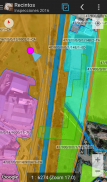
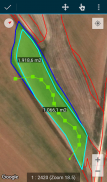
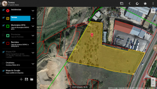
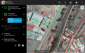
モバイル カバレッジが不十分な多くのフィールド領域では、CartoDruid はデバイスに保存されているラスター レイヤーとベクター レイヤーの視覚化を可能にすることで信頼性の高いソリューションを提供します。画面上に直接描画するか、埋め込みまたは外部の GPS を使用して、新しいジオメトリ (エンティティ) を作成できます。
CartoDruid はユーザーフレンドリーで、事前の GIS 知識を必要としないため、フィールド情報を管理する人なら誰でも簡単に構成して使用できます。生成されたデータは、外部アプリケーションで使用するためにエクスポートできます。
CartoDruid の機能は次のとおりです。
オンライン Google マップの視覚化。
SpatiaLite データベースでのベクトル地図作成の使用。
RasterLite データベースからのラスター画像のサポート。
オンライン WMS サービスの利用。
デバイス上の新しいレイヤーの作成と構成。
SQL クエリに基づくフィルタリング、シンボル、ラベル付け、検索、および識別フォーム。
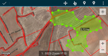
属性の編集とジオメトリの手動描画。
GPS ベースのジオメトリの描画と編集。
高度なジオメトリ編集ツール。
地理参照データやエンティティへの画像の関連付けなどのデータ保存機能。
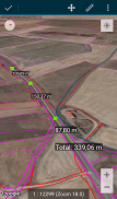
SIGPAC 検索、測定ツール、ナビゲーション補助、ブックマーク管理などの追加ツール。
複数の形式でのインポートおよびエクスポート機能。
実験的機能としての TOC 管理と SHP ファイルのサポート。
レイヤー操作コントロール。
CartoDruid は、位置追跡に基づいて機能を作成するためにバックグラウンド位置サービスを使用します。ユーザーの位置情報は、ジオメトリ頂点の作成またはマップの位置決めにのみ使用され、データはローカルに保存され、デバイスの外部には送信されません。プロジェクトフォルダーを削除すると、データを簡単に削除できます。
機能の完全なリスト、ダウンロード可能なサンプル、および開始ガイドについては、www.cartodruid.es にアクセスしてください。
CartoDruid - GIS オフライン ツール - バージョン 0.63.3
(12-06-2025)CartoDruid - GIS オフライン ツール- APK情報
APKバージョン: 0.63.3パッケージ: es.jcyl.ita.crtdrdCartoDruid - GIS オフライン ツールの最新バージョン
他のバージョン


同じカテゴリのアプリ

その他のおすすめ...


